The Unique Maps Co.
Old Map of Emporia, Kansas by USGS, 1957 – Cottonwood River & Flint Hills
Old Map of Emporia, Kansas by USGS, 1957 – Cottonwood River & Flint Hills
Couldn't load pickup availability
The original title, “Emporia,” names a place whose modest scale belies its importance in the geography of east-central Kansas. Created in 1957 and published with a 1958 imprint, this US Geological Survey 1:24,000 topographical map captures Emporia and its surrounding countryside at a precise mid-century moment. The city appears as both a commercial hub and a gateway to the rural landscape around it, with roads, railroads, waterways, and cultivated land drawn into a single measured composition. At this scale, the map has an intimate authority: individual drainage lines, street patterns, transportation corridors, and subtle elevation changes become legible, offering a portrait of a working Kansas city embedded in prairie, farmland, and river country.
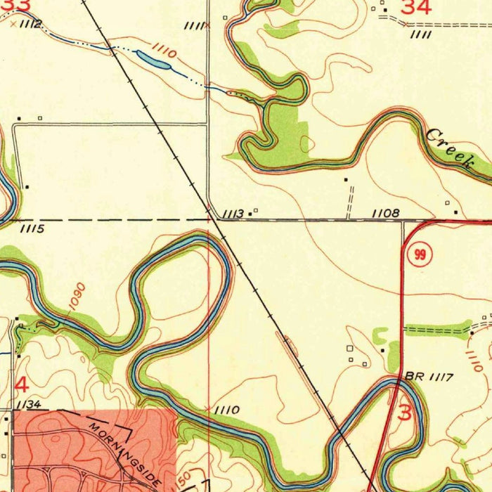
Produced by the US Geological Survey, the map reflects the agency’s exacting postwar cartographic standards. The USGS had become the nation’s preeminent mapper of terrain, water, settlement, and infrastructure, and its quadrangle maps were essential tools for engineers, planners, scientists, landowners, and travelers. Here, conventional topographic symbols are used with quiet sophistication: contour lines describe the land’s rises and falls, blue waterways trace the drainage system, black and red linework distinguishes cultural features and roads, and green areas mark parks or wooded ground. The result is both scientific and elegant, a disciplined visual language designed to make the American landscape knowable in fine detail.
Emporia’s landscape is defined by gentle relief rather than dramatic topography, and the contouring on this map reveals that subtlety beautifully. The region lies within the broader prairie environment of eastern Kansas, where low hills, shallow valleys, and open agricultural land form a terrain of gradual transitions. The Cottonwood River and associated drainage features provide the principal natural structure, cutting across the landscape and organizing settlement, roads, and fields around water and low ground. These riverine corridors were historically vital, shaping travel routes, farming patterns, and the placement of bridges, mills, and later transportation lines. The map’s contours and waterways quietly record that relationship between human use and natural form.
The city of Emporia itself appears as a node of education, commerce, and movement. Founded in the nineteenth century and long associated with civic ambition, journalism, and higher learning, Emporia developed into one of Kansas’s notable regional centers. Emporia State University, known for its roots in teacher education, helped give the city an intellectual identity that distinguished it from many surrounding market towns. By the late 1950s, the city stood at the intersection of older railroad-era development and the expanding automobile age. The map’s depiction of highways, local roads, rail lines, and urban blocks captures this layered infrastructure, showing a community shaped by both regional trade and modern mobility.
As a historical document, this map offers a richly detailed snapshot of Emporia before later decades of suburban expansion, highway alteration, and changing land use transformed parts of the surrounding area. Rural roads, farmland, parks, railroads, river crossings, and the city’s built fabric are fixed here with the understated precision characteristic of USGS mapping. Its value lies not only in what it names, but in what it measures: the relationship between settlement and slope, water and road, town and countryside. For collectors drawn to Kansas history, American surveying, or the visual beauty of technical cartography, “Emporia” presents a remarkably evocative image of place at mid-century.
Cities, towns and places on this map
- Emporia, Kansas
- Cottonwood River
- Multiple roads and highways, including the major route running through the area
- Railroads
- Parks and green spaces
- Surrounding rural areas and farmland
- Potential landmarks not specifically identified on the map
Historical context & cartographic details
- Historical 1:24,000 topographical map of Emporia, Kansas and the surrounding area
- Created in 1957 and published in 1958
- Produced by the US Geological Survey (USGS)
- Uses color-coded cartography to indicate different topographical features
- Includes contour lines showing elevation changes across relatively flat terrain with gentle hills
- Shows water bodies and drainage features in the surrounding landscape
- Provides a snapshot of local geography and human development in the late 1950s
- Reflects an area that may have changed since publication due to urban development, land use changes, and environmental factors
Looking for a particular place? Review the detailed images to confirm that the town, landmark or feature you have in mind appears on the map. If you are unsure, ask our workshop to check before you order.
Detailed maps are especially rewarding at larger sizes, where names, boundaries and decorative features have more room to be appreciated. Use the close-up preview and size guide to choose the right scale for your wall.
This map looks amazing at sizes all the way up to 50in (125cm). If you are looking for a larger map, please get in touch.
The model in the listing images is holding the 16x20in (40x50cm) version of this map.
Where personalisation is available, you can add a short title or dedication, mark one meaningful place, or request one considered visual detail. See personalised map examples.
Every piece is printed to museum-grade archival standards using fade-resistant pigment inks on acid-free matte paper. Choose an unframed map print, framed map or canvas using the finish options above. Framed maps use crystal-clear optical acrylic and arrive ready to hang.
With its rich detail and strong sense of place, this map makes a considered gift for a new home, anniversary, retirement or anyone with a personal connection to the area shown. Still deciding? Explore our collection of rare old and vintage maps to discover another place, period or style.
Share