The Unique Maps Co.
Old Map of Bowling Green, Kentucky by USGS, 1923 – Barren River & Smiths Grove
Old Map of Bowling Green, Kentucky by USGS, 1923 – Barren River & Smiths Grove
Couldn't load pickup availability
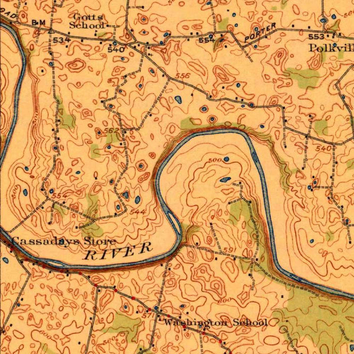
Published in 1923 by the United States Geological Survey, “Bowling Green” presents a finely observed topographical portrait of south-central Kentucky at a scale of 1:62,500. Centered on the city of Bowling Green, the map captures the surrounding country at a moment when rural settlement patterns, early road networks, farms, streams, and small communities still defined the landscape. Its title is spare and authoritative, in the classic USGS manner, allowing the geography itself to command attention. Contour lines articulate the rolling uplands and shallow valleys around the Barren River, while roads and trails thread between settlements and cultivated land. The result is both a practical scientific document and a richly atmospheric record of the region before later twentieth-century expansion reshaped its edges.
The US Geological Survey, founded in 1879, became one of America’s great cartographic institutions, producing maps that combined field science, engineering precision, and understated visual elegance. This Bowling Green sheet belongs to that tradition of disciplined observation, in which every contour, stream, road, and settlement is part of a larger national project to understand the terrain of the United States. USGS topographic maps were indispensable to geologists, planners, surveyors, travelers, and local officials, but they now also serve as historical artifacts of exceptional depth. Their quiet design language—measured linework, clear typography, systematic symbols, and subtle elevation modeling—gives them a refined authority. In this map, scientific purpose and regional character meet with particular grace.
Bowling Green itself appears as the principal urban focus, positioned amid the waterways and transportation routes that shaped its growth. By the early 1920s, the city had already become an important Kentucky center, yet the surrounding map still reveals a predominantly rural world of farms, wooded tracts, minor roads, and dispersed communities. Nearby Smiths Grove and Fertile Valley are shown within this broader landscape of small settlements and working countryside, each connected by an intricate web of lanes and routes. The map evokes a time when local movement followed the contours of the land: roads bending around hills, streams, and cultivated fields. It is a quietly vivid snapshot of regional life before highways, suburbs, and modern infrastructure transformed the area.
The Barren River and its tributary streams provide much of the map’s geographical drama, carving through the terrain and organizing the settlement patterns around them. The surrounding topography is rendered through carefully spaced contour lines, revealing the hills, valleys, and elevation points that define the Bowling Green region. These contours do more than indicate height; they suggest the lived texture of the land, from low-lying river corridors to higher ridges and gently undulating farmland. Rock formations and notable relief features emerge through the disciplined language of topographic mapping, giving the sheet a layered geological interest. Forested areas, unnamed streams, and rural landmarks add further texture, creating a portrait of a landscape both settled and deeply shaped by natural forces.
As a historical document, this 1923 Bowling Green map preserves the region at a pivotal stage between nineteenth-century rural patterns and the accelerated modernization of the twentieth century. Its roads and trails predate many later alignments, while its distribution of farms, waterways, and smaller communities records a landscape still closely tied to agriculture and local movement. The map’s value lies not only in its depiction of a place, but in its ability to reveal change: what had been built, what remained open, and how people inhabited the land before the pressures of urban growth intensified. Elegant, exacting, and quietly evocative, it offers a rare view of Bowling Green and its surroundings as both geography and memory.
Cities, towns and places on this map
- Bowling Green
- Barren River
- Fertile Valley
- Smiths Grove
- Rock formations labeled with contour lines
- Various smaller roads and trails
- Nearby forested areas
- Local farms and rural settlements
- Waterways and unnamed streams
- Notable elevation points indicated by contour marks
- Surrounding rural communities and landmarks
Historical context & cartographic details
- Produced by the US Geological Survey (USGS)
- Created in 1923
- Historical topographical map at a scale of 1:62,500
- Shows Bowling Green, Kentucky and the surrounding area
- The US Geological Survey has been known for detailed scientific mapping and cartographic excellence since its founding in 1879
- Uses traditional topographic shading to indicate elevations
- Includes detailed road and stream networks
- Features contour lines to illustrate elevation changes, hills, and valleys around Bowling Green
- Provides a snapshot of Bowling Green in the early 20th century
- Offers insight into regional development and land use before later urban expansion and modernization
Looking for a particular place? Review the detailed images to confirm that the town, landmark or feature you have in mind appears on the map. If you are unsure, ask our workshop to check before you order.
Detailed maps are especially rewarding at larger sizes, where names, boundaries and decorative features have more room to be appreciated. Use the close-up preview and size guide to choose the right scale for your wall.
This map looks amazing at sizes all the way up to 50in (125cm). If you are looking for a larger map, please get in touch.
The model in the listing images is holding the 16x20in (40x50cm) version of this map.
Where personalisation is available, you can add a short title or dedication, mark one meaningful place, or request one considered visual detail. See personalised map examples.
Every piece is printed to museum-grade archival standards using fade-resistant pigment inks on acid-free matte paper. Choose an unframed map print, framed map or canvas using the finish options above. Framed maps use crystal-clear optical acrylic and arrive ready to hang.
With its rich detail and strong sense of place, this map makes a considered gift for a new home, anniversary, retirement or anyone with a personal connection to the area shown. Still deciding? Explore our collection of rare old and vintage maps to discover another place, period or style.
Share